
-
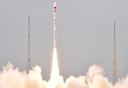
The Hong Kong University of Science and Technology (HKUST) announced today, that it would launch a multispectral optical satellite with Chang Guang Satellite Technology Company Ltd (Chang Guang) on Friday from the Jiuquan Satellite Launch Complex in Gansu. The "HKUST-FYBB#1" satellite will be utilized to track remote sensing data relevant to the global environment, disasters, and sustainable development. The launch also represents HKUST's first step toward constructing a remote sensing satellite constellation and a complete environmental monitoring and catastrophe forecasting system, since it is the first institution in Hong Kong to launch a satellite mission. The multispectral optical satellite, which will be launched for research purposes on Friday, is the most sophisticated sort of civilian satellite. The spatial resolution of the remote sensing pictures it captures is 0.5 meters, which is 20 times greater than data from the European Space Agency's Sentinel-2 optical satellite that is publicly available. It has an imaging swath of more than 150 kilometers, which is similar to the newest generation of US land satellites.
The satellite is called "HKUST-FYBB#1" in honor of Mr. Francis YIP Chi-Hung and his wife, Mrs. Catherine YIP NG Bun-Bun, for their generous gift and support for the launch. HKUST will initially utilize the satellite data to create a digital map twin system that covers all slopes in Hong Kong for the monitoring of their surface conditions, as well as the simulation and showing of the process of landslide disasters and societal responses to emergencies. This is done in the hope of enhancing coordination and decision-making in disaster response and management. HKUST signed an agreement earlier with Chang Guang, the first commercial remote sensing satellite company in Mainland China. Apart from the launching of “HKUST-FYBB#1”, HKUST and Chang Guang will venture into a long-term, extensive and multi-facet collaboration in satellite research and development for carbon emission and its data application.
Combining HKUST’s scientific research capability and achievements in meteorology, oceanography and environmental protection, as well as remote sensing data obtained from Chang Guang’s 108 orbiting satellites, which form the world’s largest sub-meter level commercial remote sensing satellite constellation “JiLin-1”, the parties are set to build a comprehensive environmental monitoring and disaster forecasting system. The system aims to provide scientific data in support of the nation’s dual carbon policy goals, namely peaking carbon emissions by 2030 and achieving carbon neutrality by 2060. It also seeks to enhance the country’s remote sensing technology – a cutting-edge technique involving the collection of electromagnetic radiation information from space or higher altitude on Earth’s surface, as well as the processing and imaging of such data for the identification and understanding of the Earth’s environment and resources.
Rendering their full support to the satellite launch, Mr. Francis YIP and Mrs. Catherine YIP said they were delighted to facilitate the strategic cooperation between HKUST and Chang Guang. They stated, “We have seen HKUST’s indefatigable effort and determination in promoting the development of aerospace technology in Hong Kong. We will continue to support HKUST and the innovation and technology development in Hong Kong. This project marks an important milestone in Hong Kong’s aerospace development. As Hongkongers, we feel proud of our city’s progress and are deeply honored to contribute to this project. We would also like to express our gratitude to Prof. LIU Yuyi for inscribing the name of the satellite in calligraphy.”
HKUST Council Chairman Prof. Harry SHUM said, “HKUST is a staunch supporter of sustainable development and has always been active in exploring and finding solutions to global carbon emissions problems. In the face of pressing challenge of climate change, we are deeply thankful to Mr. and Mrs. Yip for their support, which allows us to commence on our remote sensing satellite program. We look forward to cooperation with the government, research institutes, enterprises and different sectors for wider application of the data we will obtain through our cooperation with Chang Guang. Together, we can make contributions to the nation’s dual carbon policy goals, our government’s carbon emissions targets, and the easing of global climate change to demonstrate our commitment in sustainable development.”
HKUST President Prof. Nancy IP also expressed her gratitude to Mr. and Mrs. Yip. She said, “HKUST strongly encourages our researchers to engage in exploratory, socially impactful frontier research projects, and to actively work with industry partners to actualize scientific discoveries to address global challenges such as natural disasters and climate change. We are excited to partner with Chang Guang to drive aerospace innovation and contribute to the national development strategy. HKUST will fully leverage its research capabilities and continue to promote cooperation among various academic, research, and industry sectors to strengthen our aerospace industry and achieve the nation’s dual carbon policy goals.”
Chang Guang Deputy General Manager Mr. CHEN Maosheng said, “The strategic cooperation agreement signed between HKUST and us aims to foster deep collaboration in the fields of scientific satellite development and remote sensing data application. Leveraging our research and development ability in satellite manufacturing and combining it with the remote sensing application expertise of HKUST, the two parties will jointly develop greenhouse gas remote sensing monitoring satellites. We will continue to engage in extensive cooperation in the field of new remote sensing satellites, promoting the joint development of the aerospace industry in Mainland and Hong Kong, and enhancing the remote sensing data service capabilities in Hong Kong and the Greater Bay Area.”
Vice President for Institutional Development at HKUST Prof. WANG Yang, the plan's driving force, stated, "This satellite launch is the first step toward HKUST's ambitious aim of creating a comprehensive remote sensing satellite constellation." Our goal is to create cutting-edge multimodal spatial remote sensing technologies, such as unique carbon monitoring methodologies and data processing software. We hope to provide services for disaster management, smart city development, and sustainable resource management using our broad sensing capabilities. This program will help both the Greater Bay Area and the country by aligning with the national dual-carbon strategy aim and advancing environmental monitoring satellite remote sensing technologies. Our ultimate goal is to contribute to domestic and global sustainable development.
🍪 Do you like Cookies?
We use cookies to ensure you get the best experience on our website. Read more...